The Bird City storm of June 3 (June 3/4 UTC) produced a substantial number of inverted polarity intracloud discharges but no cloud-to-ground (CG) lightning. (The latter was indicated both by the National Lightning Detection Network data and by observers who were under the storm.) Normal-polarity storms inevitably produce -CG discharges unless they are only marginally electrified and generate only a few intracloud flashes. While it was usually the case that inverted-type storms produced +CG discharges, there appeared to be notable exceptions. Another storm that produced copious inverted-polarity intracloud lightning but apparently no CG discharges occurred on June 12, west of Sharon Springs, KS. Also, the tornadic storm of June 29 produced copious intracloud lightning but only a couple of CG discharges (of positive polarity), prior to intensifying and becoming tornadic. There is some suggestion in the mapping observations from other storms that +CG discharges involve a lower negative charge. Such a charge would be analogous to the lower positive charge of normally electrified storms that is typically involved in -CG lightning. This possibly indicates that inverted-type storms may not produce +CG discharges unless the storm develops lower negative charge.
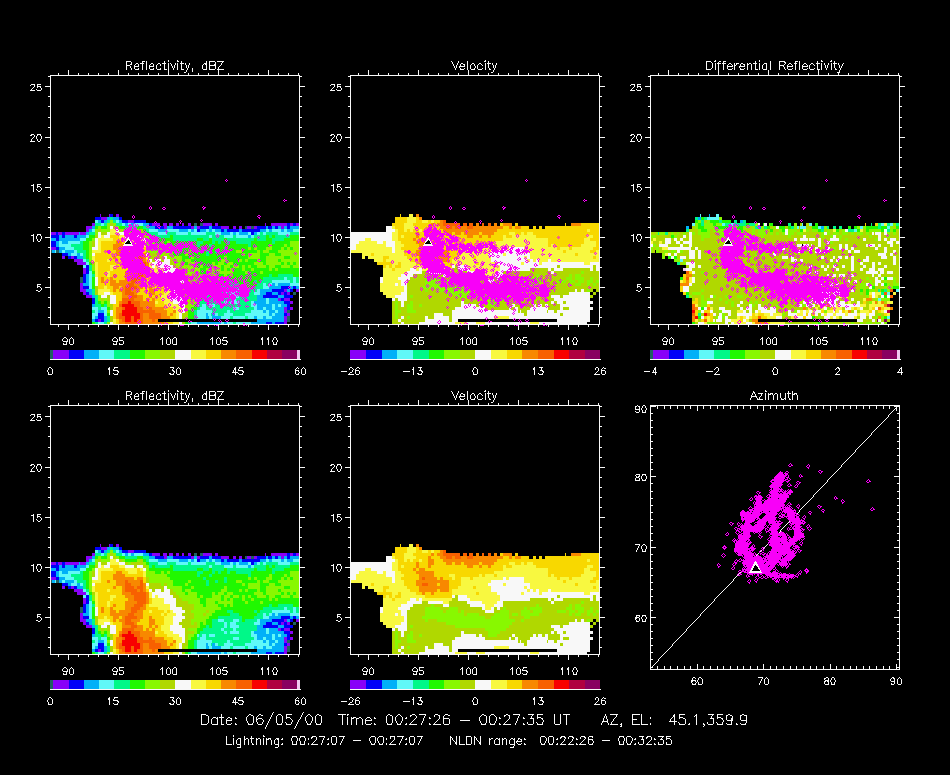
Here are some sample observations from the Bird City storm. They are centered around the time of a balloon flight through the storm by the University of Oklahoma/National Severe Storms Laboratory group, which measured the electric field profile inside the storm. The first figure, presented below, shows an inverted-polarity intracloud discharge overlaid on a vertical radar cross-section from the CHILL radar. The discharge started in the upper part of the storm (at the location indicated by the black triangle) and initially developed downward in the cloud. It was a classic bi-level discharge of inverted polarity, which were literally commonplace during STEPS. The discharge started at the top of the main precipitation shaft in the storm and developed downward through the precipitation before turning horizontal below 6 km altitude.
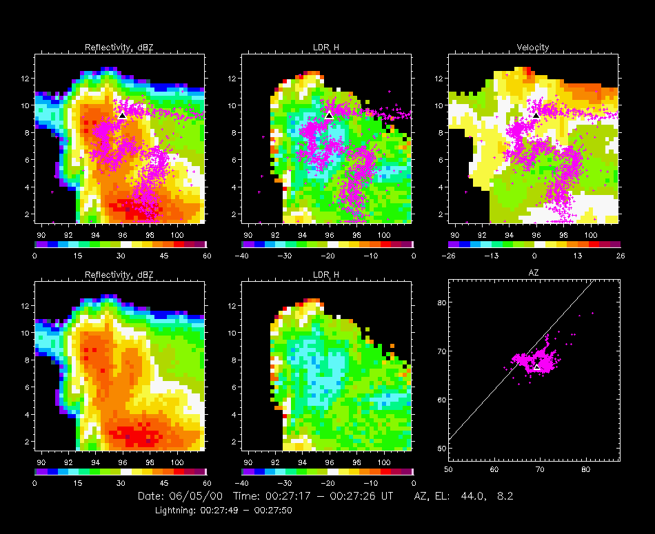
The figure below shows another inverted polarity discharge that began high up in the storm but that followed a tortuous path through the cloud. We have zoomed in on the main storm cell to better show the structure. Although it appears that the discharge channel went to ground, the other observations indicate that it did not. (This will be checked with fast electric field change measurements from made at the interferometer site.) The initial downward development was through the northeastern precipitation shaft of the storm. The channel then developed back up through a side precipitation region and then eventually vertically downward toward ground. The NSSL/OU balloon traveled up through the main precipitaton shaft, as we show next.
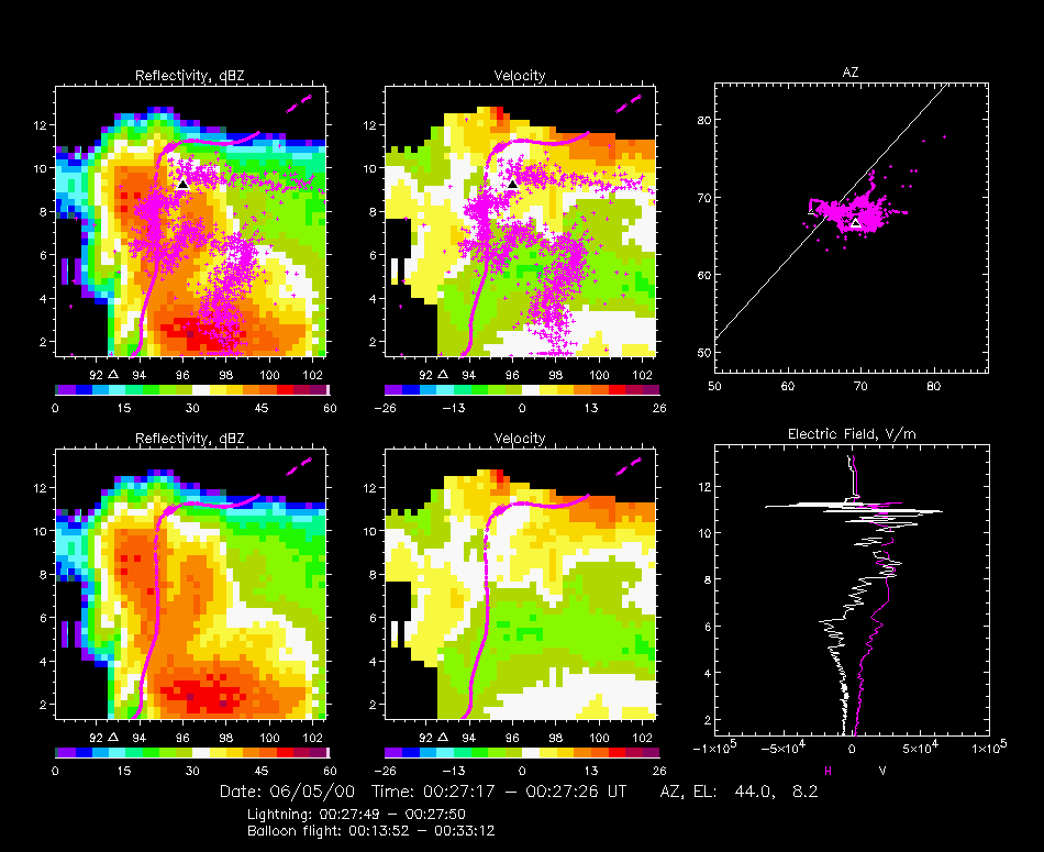
In the next figure, the trajectory of the NSSL/OU balloon is added to the observations, along with the electric field profile measured along the path. The balloon ascended in or near the plane of the radar scan, through the side of the main precipitaton shaft. At the time of the radar scan the balloon had just finished its fast upward ascent and was just above the precipitation shaft at the bold part of the trajectory. The lightning discharge occurred about 30 seconds later. The initial downward part of the discharge was along the upward path followed earlier by the balloon. Numerous discharges had occurred during the balloon ascent, as indicated by the sudden changes in the vertical field component in the electric field profile. A complete analysis of the storm will include analyzing all of its lightning discharges and correlating/comparing this information with the balloon observations.
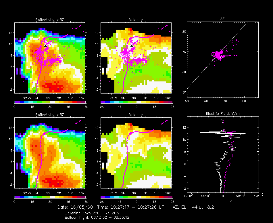
The discharge shown in the picture below occurred one minute before the radar scan, when the balloon would have been lower down in the precipitation shaft. This discharge exhibited similar development to the one discussed above, indicating that the charge was systematically regenerating in the storm.
![[Go Back to STEPS 2000]](images/goback.jpg) Go Back to STEPS 2000
Go Back to STEPS 2000