Overview of the Lightning Activity
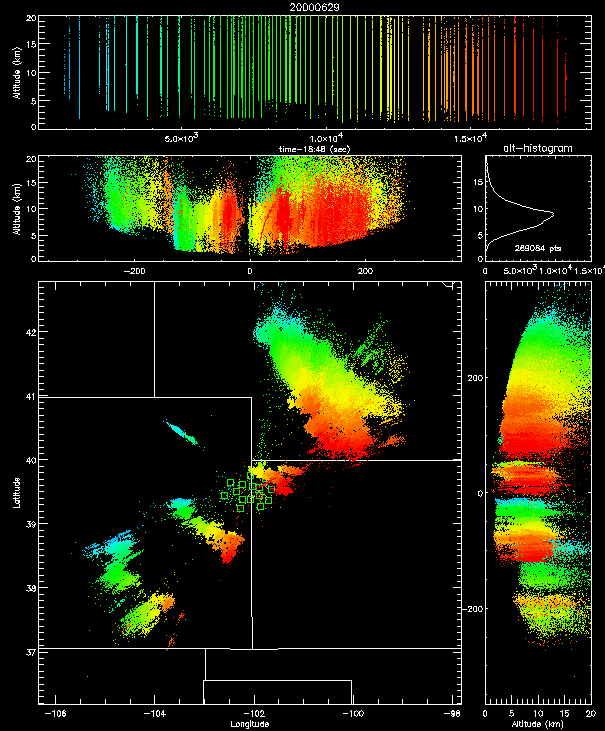
Shown below is an overview of several hours of lightning activity on June 29 from the real-time display. A massive storm system in Nebraska developed southward with time and was near the Nebraska-Kansas border by the end of the time interval shown (2400 UTC, 6 PM MDT). The storm of interest was the relatively small but intense system that developed in the northern part of the STEPS area, near the NB-KS-CO tri-state boundary point. This was a supercell storm that developed southeastward with time and produced an F1 tornado between 23:29 and 23:44 UTC. The tornado was on the ground for about 15 minutes and moved from west to east, as shown later. It was readily visible from the National Weather Service location on the north side of Goodland.
The observations discussed below are from examining only a small amount of data from the storm. Much more information is available, and the recollections given below are subject to correction when the data are analyzed in more detail. The storm was electrified and producing lightning for more than an hour before producing the tornado. During this time the storm produced only a few cloud-to-ground discharges, all of positive polarity. The storm was producing copious intracloud lightning, however. Electric field change measurements made at the Tech interferometer site indicated that the intracloud lightning was of inverted polarity. From numerous other observations in STEPS, such discharges are between negative charge at upper levels in the storm and positive charge at mid-levels, rather than the other way around. Also, individual discharges tend to develop downward with time during their initial stages rather than upward. Several other storms have been observed during STEPS which produced substantial intracloud lightning of inverted polarity intracloud lightning, but little or no CG lightning. One was the Bird City storm of June 3, discussed elsewhere in this web site.
Up to 1 inch diameter hail occurred at around 23:00 UTC (5 pm MDT) along U.S. Highway 36 east of the town of Wheeler, KS (east of St. Francis). The storm started producing numerous, concentrated +CG lightning discharges around the time that the tornado formed. The intracloud lightning continued to be inverted in polarity. The +CG lightning continued for several hours as the storm moved on through the Colby area.
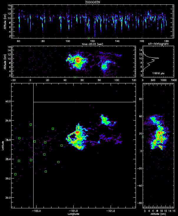
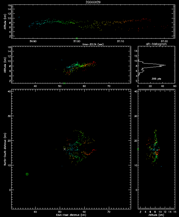
Shown below is two minutes of lightning activity between 23:24 and 23:26 UTC, shortly before the tornado formed. Of particular interest is the `hole' in the lightning activity on the west side of the storm. A similar hole was observed in an Oklahoma supercell storm in 1998 at the time of an F0 tornado. The holes appear to be associated with the updraft location. In the Oklahoma storm, the tornado formed on the west edge of the hole. The tornado formed in exactly the same location in the June 29 storm, as we will see in a later figure.
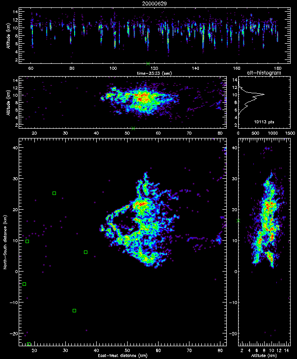
Shown below is a zoomed-in view of the lightning activity. The hole was about 5 miles (9 km) in diameter. The green `x' seen beneath the storm in the vertical cross-section panels indicates the location of a positive cloud-to-ground (+CG) discharge, obtained from the National Lightning Detection Network (NLDN). The +CG occurred at about 23:25 and went to ground on the western edge of the lightning hole. The in-cloud part of the discharge developed to the east (right) of the hole.
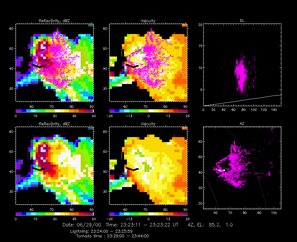
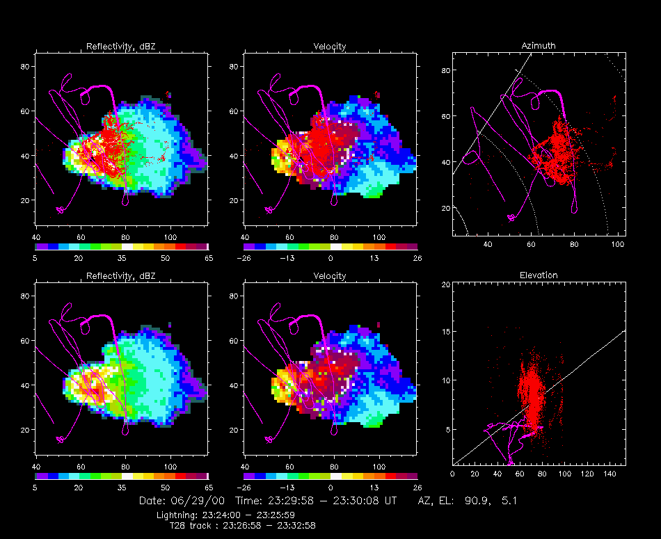
The image below shows the lightning data overlaid on a horizontal radar cross-section through the storm from the CSU-CHILL radar. The storm was 70 km ENE of the radar. Also shown is the path of the tornado (the bold black or white line). The tornado started at about 23:29, 3 minutes after the end of the lightning interval, and on the west side of the lightning hole. It traveled 5 km to the east in about 15 minutes. Measurements from the three Doppler radars will be used to reconstruct the air motion in the storm. From this the location of the updraft will be known and can be compared to the location of the lightning hole. The radar scan passed through the storm 1-2 km above ground level, well below the lightning, as indicated in the upper right panel.
Shown below is the flight path of the armored T28 aircraft overlaid on the radar echo from the tornado storm. The T28 is from the South Dakota School of Mines and Technology. It penetrated the storm several times as the storm intensified and became tornadic. The flight path is shown in both plan and elevation views and is compared with the lightning in the top panels. The bold part of the track indicates the location of the T28 between 23:27 and 23:33, just before the last two passes through the storm.
The next overlay shows the +CG discharge described earlier. The triangle indicates where the discharge started inside the cloud. From the NLDN data, the discharge went to ground almost directly below the starting point. The in-cloud channels developed eastward (to the right) in the storm, into a region of weaker radar reflectivity. The flash structure is shown in more detail in the next figure. The radar scan in this case was at an elevation angle that passed through the storm between 5 and 8 km altitude, slightly below most of the incloud lightning channels.
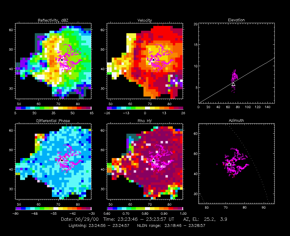
Below is a detailed picture of the +CG discharge. Again, the green `x' shows the NLDN ground strike location. The channel between the cloud and ground radiates weakly for positive discharges and is not located by the mapping system. Strong radiation is produced by the in-cloud part of the discharge, whose channels are well-located by the mapping system. The east-west vertical cross-section indicates that the lightning removed positive charge from between 6 and 10 km altitude MSL to the east (right) of the ground contact point. The colors indicate the time sequence of the points and show that the discharge developed from left to right with time.
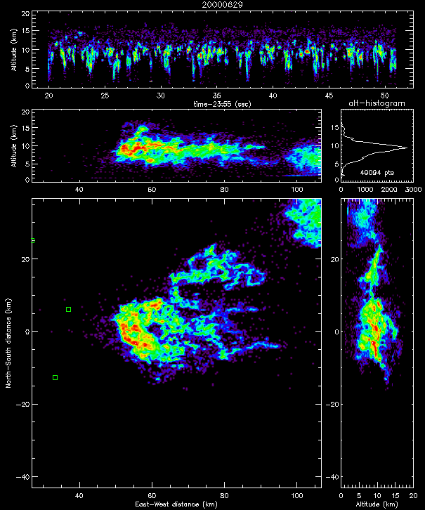
The next image shows 30 seconds of the overall lightning activity 30 minutes later in the storm, shortly after the tornado. The lightning hole is smaller, about 5 km in diameter, but is still present. Also, most of the lightning activity is now on the west side of the hole.
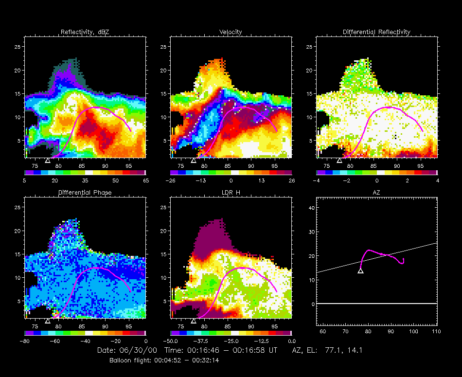
The next figure is quite nice. It shows the path of one of the electric field measuring balloons launched into the storm by the University of Oklahoma/National Severe Storms Laboratory group. The trajectory is overlaid on a vertical cross-section through the storm, again from the CHILL radar. There is a lot of interesting information in these pictures. The inflow or updraft region is on the left side of the storm, as indicated by the characteristic `overhanging' structure of the echo in the lower left part of the scan. The Doppler data show the updraft very nicely, as the upward slanted blue column in the velocity panel. (In the velocity data, the red colors normally indicate particle motion away from the radar and the blue colors indicate motion toward the radar. In this case, however, the large blue region correspond to even stronger motion away from the radar due to aliasing or `folding' of the velocity measurements.) The radar reflectivity is relatively weak in the updraft and stronger in the back side of the storm, to the right of the updraft, corresponding to the outflow region.
The balloon ascended along the right hand edge of the updraft. Data from the balloon instruments show that its ascent rate reached 100 mph in the upper part of the updraft region! The bulge at the top of the balloon trajectory shows where the instrument was at the time of the radar scan. Shortly before the bulge, the balloon had passed through a region of strong reflectivity, undoubtedly hail. The hail appeared to puncture the polyethylene balloon, as it subsequently started to descend gradually through the back side of the storm. The trajectory is shown in plan view in the lower right panel, relative to the scan plane of the radar.
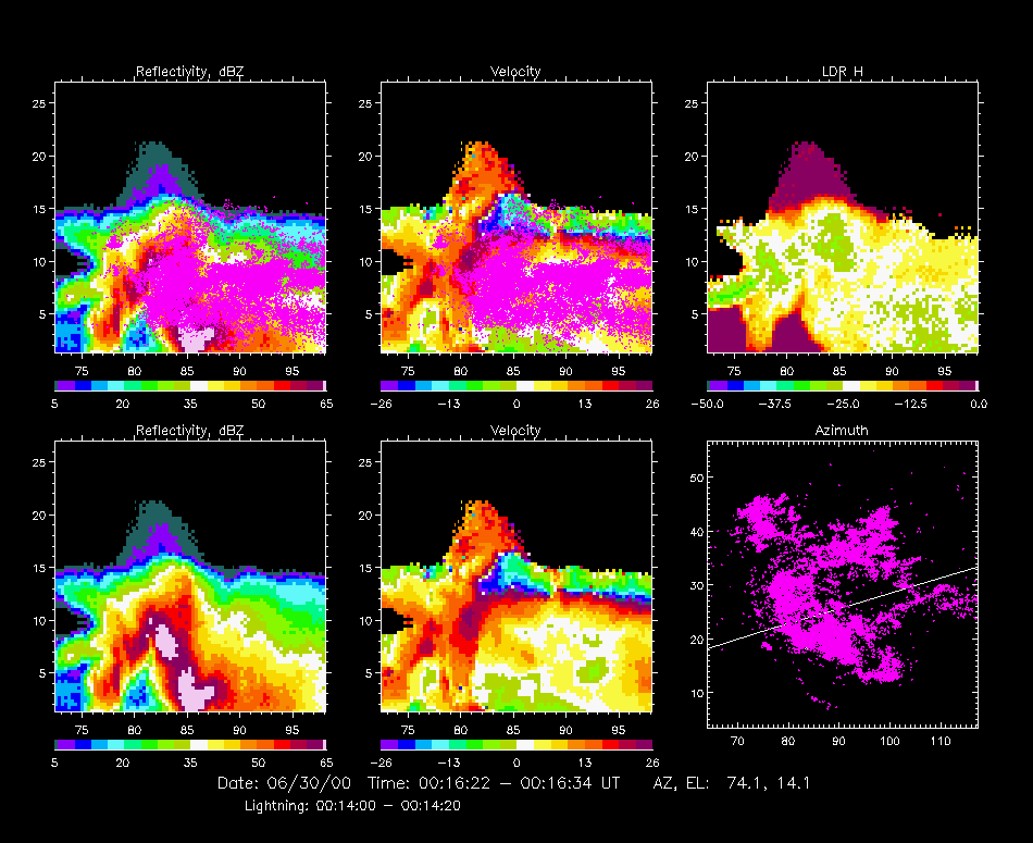
The next figure shows the lightning activity during a ten-minute time interval overlaid on a vertical radar cross-section at a slightly different azimuth than before. Most of the lightning sources are in the intense (> 65 dBZ) reflectivity hail falling out of the updraft. The lightning activity is more layered further to the east in the storm. An interesting feature are the small number of lightning sources along the upper boundary (somewhat hard to see in the figure). These probably indicate the presence of an electrical `screening' charge in this part of the storm, which is penetrated by some of the discharges. Another interesting feature is the sharp decrease in the number of lightning sources below 3 to 4 km altitude.
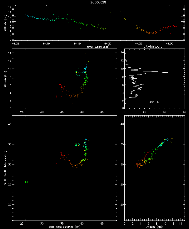
The final figure shows an interesting lightning discharge that we happened to spot in perusing some of the real-time mapping data. (Only one of many, many interesting discharges seen in STEPS.) It is an example of an inverted polarity intracloud discharge that started high in the storm and developed downward with time. The initial downward development was followed by activity above the source region and then by renewed breakdown at the bottom of the channel, which wound up progressing back upward in the storm. Overall, the discharge looked like the letter `J'.
![[Go Back to STEPS 2000]](images/goback.jpg) Go Back to STEPS 2000
Go Back to STEPS 2000