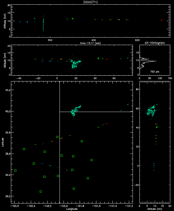
Shown below are real-time observations on July 12 which show the passage of three aircraft over the mapping network. The weather in the Goodland area was clear and bright, but with a high layer of cirrus clouds. A small storm was occurring over the Kansas/Nebraska border, as indicated by the lightning discharge seen in the figure.
The data cover a 12 minute time interval beginning at 19:17:12 UTC (1:17 pm MDT). The real-time system was monitoring any activity in the area by processing ~10 seconds of data about 3 times a minute. The aircraft tracks show up as the intermittent, slightly curved lines in the plan view, and as dotted or dashed lines in the vertical cross-section views. The airplanes were flying through the cirrus cloud layer and were being continually charged by collisions with the ice crystals in the cirrus. This causes the aircraft to give off a sequence of small electrical discharges or sparks which are readily located by the mapping system. The direction of travel is indicated by the colors, which are used to encode time.
Two of the aircraft were travelling from west to east (left to right), while the third traveled into the area from the northeast. The first aircraft is shown in blue and traveled ESE over the center of the network at about 9.5 km altitude (31,000 ft). The second is shown mostly in orange and traveled ENE over the northern end of the network at about 11 km altitude (36,000 ft). The third aircraft is shown in green and approached the network from the NE between 11 and 11.5 km altitude. A final segment of the plane 2 track is shown in red, near the location of the final segments of the plane 3 track, northeast of the network. The slightly curved paths of planes 2 and 3 indicate they were probably flying around the lightning-producing storm on the KS/NB border.
![[Go Back to STEPS
2000]](images/goback.jpg) Go Back to STEPS 2000
Go Back to STEPS 2000