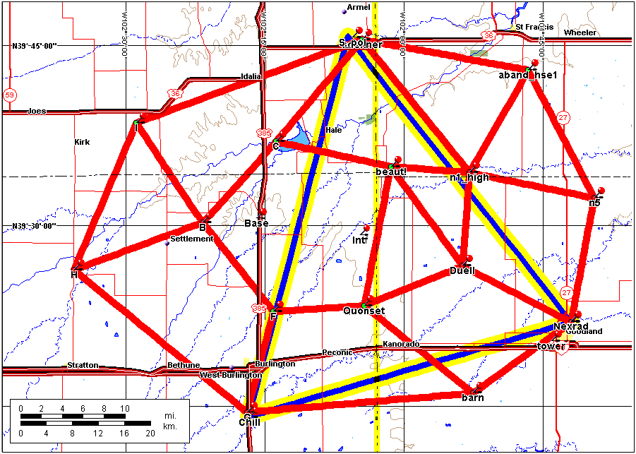
A total of 13 lightning mapping stations were deployed over a four-county area in northwest Kansas and eastern Colorado from mid-May to mid-August 2000. The map presented below shows the locations of the mapping stations and of the radars used during STEPS. The radars were deployed on 60 km baselines, indicated by the blue-yellow triangle. The lightning mapping stations were deployed over an area about 80 km in diameter. The New Mexico Tech lightning interferometer was operated in the center of the network, near the Kansas-Colorado border (Intf).
Each of the stations was linked back into an operations center next to the National Weather Service Office in Goodland, on the lower right of the map. The figure at the bottom of the page shows the communications links used to do this. Most of the links were 2.4 GHz WaveLan high-speed ethernet connections and provided 4 Mbit/second data transfer rates.
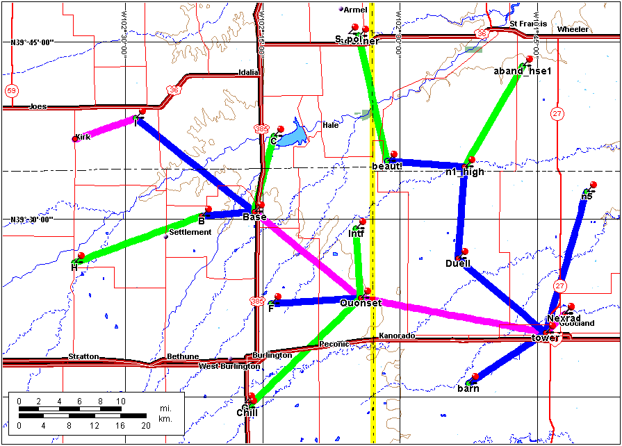
Initial layout of the communications network, used to remotely monitor and control each station and to transmit data back to the operations center in Goodland. Most of the links were implemented using WaveLan/Orinoco 2.4 GHz wireless ethernet cards and directional parabolic grid antennas. These links gave a data throughput rate of 4 Mbits/second. Two of the links utilized high speed (115 kBaud) Freewave wireless modems. Two of the links were changed because they could not be established: Data coming into the Quonset location was routed to Duell rather than directly into Goodland, and data from Site G near CHILL was routed via F rather than directly to the Quonset.
We thank the following persons for allowing us to operate the stations on their property and places of work: Roger and Donna Karspeck, Gene Davis, Richard Lundien, David Uphoff (Bonny State Park), Larry Mack (Burlington/Kit Carson County Airport), Mike and Penny Morris, David Whipple, Dave and Paula Wingfield, Jim and Judy Soehner, Robert Daise, Melvin Sall, Steve and Colleen Duell, Rod Lindsten, Bill Gannon and Sharon Hall, and the City of Goodland. We also thank Mark Reasoner and the Kansas National Guard for allowing us to locate our operations trailer at the Armory in Goodland, Richard Hoffman and Larry Keirns of the Northwest Kansas Technical School in Goodland for their assistance in obtaining lodging, Larry and Phyllis Dickey of Goodland for their substantial assistance and interest in the project, and Dennis Rouse of Burlington for electrical contracting work. Last but not least, we thank the many staff of the National Weather Service Office in Goodland (Llyle Barker, Kevin Lynott, Joyce Hayden, and Scott Mentzer to name a few) for their interest in the project and their substantial expertise and help in making it a success.
![[Go Back to STEPS 2000]](images/goback.jpg) Go Back to STEPS 2000
Go Back to STEPS 2000